
 Nederlands
 Español
 Français
Minnesota Land Purchase of Ambrose and William Van Landschoot
Frontier land, speculation, and a vanished parcel in New Canada Township
Contemporary records indicate that Ambrose B. and William H. Van Landschoot did not limit their activities to a single location. In addition to their purchase in Ramsey County, Minnesota, they are known to have acquired land in Missouri and Illinois as well. This broader pattern of land ownership strongly suggests a deliberate strategy of frontier investment and speculation, rather than permanent settlement on any one tract.
In May 1856, the brothers Ambrose B. Van Landschoot and William H. Van Landschoot acquired an eighty-acre parcel in Ramsey County, Minnesota Territory. The deed describes the property with the precise language of the American survey system: the south half of the southwest quarter of Section 13, Township 29 North, Range 22 West. On paper, this was a clearly defined tract of land; in reality, it lay in a region that still belonged to the raw edge of the frontier.
By combining an old township map with a modern overlay, the parcel can now be placed with surprising accuracy in the area around County Road B East and Edgerton Street North, north of present-day Saint Paul. What is now a landscape of roads, residential blocks, and green strips was, in the mid-nineteenth century, still largely a quiet and unsettled expanse of woodland, marsh, and prairie.
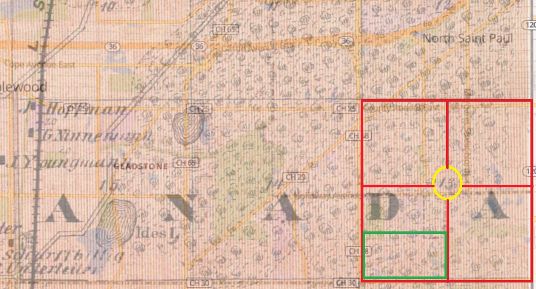
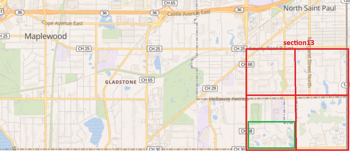
What makes this purchase especially interesting is that later maps do not show the parcel as a clearly developed farmstead. Instead, the area still appears sparsely improved, which strongly suggests that the brothers did not buy the land to settle there themselves. The evidence points rather to a purchase made as an investment, in the hope that frontier land would rise in value as settlement moved outward from Saint Paul.
This interpretation becomes even more convincing when seen in a broader context. Ambrose and William were not active in Minnesota alone. They also acquired land in Illinois and Missouri, which suggests a wider pattern of property investment rather than simple family migration from one place to another. Their Minnesota parcel thus appears to have formed part of a larger strategy, combining opportunity, mobility, and a keen sense of where expansion might bring profit.
Although purchased in 1856, the tract in New Canada Township seems to have remained largely undeveloped for many years. The absence of a clearly named farm or improved holding on later mapping supports the view that the land was acquired as speculative frontier property.
The contrast between past and present is striking. In the nineteenth century, this was still an almost empty surveyed square on the edge of settlement; today, the same ground is absorbed into the suburban fabric north of Saint Paul. The deed of 1856, however, preserves the moment when that future landscape was still only a possibility, and when two brothers from the Van Landschoot family chose to stake their claim in it.
Sources:
Ramsey County deed dated 12 May 1856 FS film #008592014
img 472/730
Historical township mapping of New Canada Township
Modern map overlay of the original parcel location